MULHOLLAND DRIVE—The carotid artery of our community. We gnash our teeth at the prospect of having to negotiate traffic on the valley floor or on the city side.
For those of us who have been paying attention, two weekends ago DOT put up plastic barricades and orange traffic cones at Laurel Canyon and Coldwater, closing off Mulholland. It wasn’t more than a few hours and the cones and barricades had been moved; cars were zooming through the intersections at will. Next came more cones, barricades and cops. This seemed to work a little better, but southbound traffic was seriously messed up.
 |
While it’s true that the road is closed to traffic, it’s open to pedestrians. So curiosity sent me off on one of my missions —to investigate this pesky sinkhole. The Parking Enforcement officer at that the east end at Mulholland and Skyline told me that they couldn’t put up a K-rail to block traffic because of the potential liability. I can just envision some jerk zooming along Mulholland only to collide with the K-rail. What’s better, the lawsuit or the salary of the Parking Enforcement officer? I’d say we’re all winners if there is one less person writing tickets.
So, where was this gargantuan sinkhole that closed off all of Mulholland? What did it look like? What was my assessment of its capacity to be fixed? For the first time since I’ve lived in the hills I walked confidently down the middle of Mulholland. The wind had cleared the skies, so the vista was beautiful. I could hear the faint hum of traffic coming up from the valley floor. With all the recent rain the roadside was covered with foot-high grass. I’d never noticed that Mulholland was pitched. It must have been 15 plus degrees. No wonder the run-off from the hills creates such a problem.
I finally made it to the sinkhole. It’s between Carl’s and Carl’s Jr. for those of you familiar with the glamorous history of Mulholland Raceway. The rest of us can think in terms of 1/3 of the distance east from the Bowmont Estates gate and Skyline. It’s Mulholland —there are no addresses as sign posts to orient you. Do the best you can.
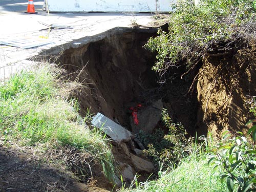
It’s a wallapalooza. I’d say a good 15 feet across the northern lip of the road, and over 15 feet deep. What you can’t see from the road is that the sinkhole has eroded dirt from underneath the roadway, with the road surface still seemingly in tact. Clearly water came rushing down the cliff on the southern side of Mulholland and accumulated in this part of the road that dips and is curved.
My assessment? We’d better get over ourselves, this one is a doozey. The city has already been out there as evidenced by Dayglo spray painted jigsaw puzzle markings all over the road. Which government agency gets first crack at this I wonder?
Over my left shoulder I hear a loud swwooooop. I flinched. I thought jeez, “some sort of propeller.” A hawk diving for prey. So put on your passigatta shoes and enjoy the stroll. Consider a closed Mulholland as an opportunity, not an aggravation.


